
Understanding the geographical, atmospheric and oceanographic processes behind tropical cyclones, their impact on India’s eastern coastline and the evolution of disaster management strategies.
GS Paper I & III | Geography | Disaster Management
1. Introduction: The Recurring Threat of Tropical Cyclones
Tropical cyclones are among the most destructive natural hazards affecting the Indian subcontinent. They cause extensive damage through high-speed winds, storm surges, torrential rainfall, coastal flooding and landslides.
India’s geographical location makes it particularly vulnerable to tropical cyclones originating over the Bay of Bengal and the Arabian Sea.
The eastern coastline, particularly Odisha, Andhra Pradesh, West Bengal and Tamil Nadu, has historically experienced significant cyclone-related disasters.
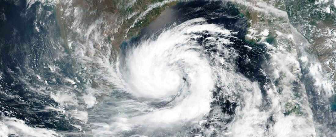
The issue has gained renewed attention with the development of Cyclone Akvan over the Bay of Bengal in November 2026.
According to the India Meteorological Department’s bulletin issued on 16 November, the system intensified from a deep depression into a cyclonic storm and was forecast to become a severe cyclonic storm on 17 November. It was subsequently expected to intensify further and approach the Andhra Pradesh coast around 19–20 November. The forecast indicated a possible landfall between Nellore and Tuni, although the precise landfall position and timing remained subject to revision. internal.imd.gov.in+2
The significance of such events extends beyond immediate weather conditions. They provide an opportunity to examine the relationship between ocean-atmosphere interactions, coastal geography, climate variability, disaster preparedness and sustainable development.
For UPSC aspirants, tropical cyclones are particularly relevant to:
- Physical geography and climatology.
- Oceanography and atmospheric circulation.
- Indian coastal geography.
- Climate change and extreme weather events.
- Disaster management and institutional preparedness.
- Coastal ecosystems and environmental protection.
2. What Are Tropical Cyclones?
A tropical cyclone is an intense, rotating, low-pressure weather system that develops over warm tropical or subtropical ocean waters.
It is characterised by:
- A central low-pressure region.
- Strong rotating winds.
- Deep atmospheric convection.
- Heavy rainfall.
- A warm central core.
- A relatively organised circulation system.
In the Northern Hemisphere, tropical cyclones rotate anticlockwise, while in the Southern Hemisphere they rotate clockwise because of the Coriolis effect.
The term used for these systems varies across geographical regions.
| Region | Common terminology |
|---|---|
| North Indian Ocean | Cyclones |
| Atlantic Ocean | Hurricanes |
| Eastern and Western Pacific | Typhoons |
| Australian region | Tropical cyclones |
Although their names differ, the underlying meteorological phenomenon is broadly similar.
3. Conditions Necessary for the Formation of Tropical Cyclones
Tropical cyclones do not develop randomly. They require a combination of oceanic and atmospheric conditions.
How do tropical cyclones form? Australian weather guide
3.1 Warm sea-surface temperatures
Warm ocean water provides the energy necessary for cyclone development.
Generally, sea-surface temperatures of approximately 26.5°C or higher favour tropical cyclone formation, provided that sufficient warm water extends beneath the ocean surface.
Warm water promotes evaporation, increasing the moisture content of the lower atmosphere.
3.2 High atmospheric moisture
Moist air in the middle levels of the troposphere supports the development of deep convective clouds.
When moist air rises and condenses, latent heat is released, providing energy to the developing weather system.
3.3 Pre-existing low-pressure disturbance
A tropical cyclone generally develops from an existing atmospheric disturbance.
This may take the form of:
- A low-pressure area.
- An easterly wave.
- A monsoon trough disturbance.
- A region of enhanced atmospheric convection.
Such disturbances provide the initial circulation around which a cyclone can develop.
3.4 Coriolis force
The Coriolis force, arising from Earth’s rotation, helps organise the rotating circulation of the cyclone.
This is why tropical cyclones generally do not develop immediately around the equator, where the Coriolis force is very weak.
Most tropical cyclones develop at least about 5° latitude away from the equator.
3.5 Low vertical wind shear
Vertical wind shear refers to changes in wind speed or direction with altitude.
Strong vertical wind shear can disrupt the vertical structure of a developing cyclone by displacing the upper-level circulation from the lower-level centre.
Relatively weak vertical wind shear is therefore favourable for cyclone development.
3.6 Atmospheric instability
The atmosphere must support the upward movement of warm, moist air.
Strong convection and the release of latent heat contribute to the formation and intensification of the cyclone.
These conditions are interconnected. Warm ocean waters alone cannot guarantee cyclone formation.National Oceanic and Atmospheric Administration+2
4. Structure of a Tropical Cyclone
A mature tropical cyclone consists of several distinct components.
UNDERSTANDING TYPHOON and how it is formed.pptx
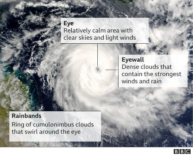
4.1 Eye
The eye is the central region of the cyclone.
It is generally characterised by:
- Relatively calm winds.
- Subsiding air.
- Comparatively clear skies.
- Very low atmospheric pressure.
The eye is surrounded by the eyewall.
4.2 Eyewall
The eyewall consists of a ring of intense thunderstorms surrounding the eye.
It contains some of the strongest winds and most intense rainfall associated with the cyclone.
The eyewall is often responsible for the most severe wind-related destruction.
4.3 Spiral rainbands
These are curved bands of clouds and thunderstorms extending outward from the central region.
They produce:
- Heavy rainfall.
- Strong winds.
- Thunderstorms.
- Localised flooding.
4.4 Upper-level outflow
As air rises within the cyclone, it spreads outward in the upper troposphere.
This outflow helps maintain the circulation by allowing rising air to escape from the central region.
5. Classification of Cyclonic Disturbances in India
The India Meteorological Department classifies cyclonic disturbances over the North Indian Ocean according to maximum sustained surface wind speed.
The classification is important for understanding the intensity and potential destructive capacity of a cyclone.
| Category | Maximum sustained wind speed |
|---|---|
| Low Pressure Area | Less than 31 kmph |
| Depression | 31–49 kmph |
| Deep Depression | 50–61 kmph |
| Cyclonic Storm | 62–88 kmph |
| Severe Cyclonic Storm | 89–117 kmph |
| Very Severe Cyclonic Storm | 118–167 kmph |
| Extremely Severe Cyclonic Storm | 168–221 kmph |
| Super Cyclonic Storm | 222 kmph or more |
rsmcnewdelhi.imd.gov.in+1
Important distinction: The above classification is based on maximum sustained wind speed, not the highest instantaneous gust recorded during the cyclone.
The wind speeds also do not independently determine the total damage. Storm surge, rainfall, coastal elevation, population density and preparedness are equally important.
6. Why Is the Bay of Bengal More Vulnerable to Cyclones?
The Bay of Bengal is generally more favourable for the development of tropical cyclones than the Arabian Sea.
Several geographical and oceanographic factors contribute to this pattern.
6.1 High sea-surface temperatures
The Bay of Bengal receives substantial solar heating, particularly during the pre-monsoon and post-monsoon periods.
Warm ocean waters provide energy for atmospheric convection and cyclone intensification.
6.2 Large-scale freshwater inflow
Several major rivers discharge into the Bay of Bengal, including:
- Ganga.
- Brahmaputra.
- Mahanadi.
- Godavari.
- Krishna.
- Irrawaddy.
Freshwater input reduces surface-water salinity and can contribute to the formation of a stable upper-ocean layer.
This can limit the vertical mixing of cooler subsurface water during strong cyclonic winds.
Consequently, warm surface waters may remain available to support cyclone intensification.
However, this is one contributing factor among several, not a sufficient explanation by itself.
6.3 Semi-enclosed geographical configuration
The Bay of Bengal is a relatively enclosed northern extension of the Indian Ocean.
Its configuration and coastal characteristics influence ocean circulation, wave propagation and storm-surge behaviour.
6.4 Shallow coastal bathymetry
The northern Bay of Bengal has extensive shallow continental shelf areas.
When a cyclone approaches such coastal regions, strong winds can push seawater towards the coast, producing storm surges.
Shallow coastal waters can contribute to the amplification of coastal inundation.
6.5 High population density in coastal regions
The northern Bay of Bengal is bordered by densely populated coastal regions of India and Bangladesh.
Low-lying settlements, agricultural land and coastal infrastructure increase the potential consequences of cyclone landfall.
6.6 Historical climatology
The IMD’s long-term cyclone climatology identifies the Bay of Bengal as the more active region of the North Indian Ocean.
Its cyclone-warning documentation records greater cyclone frequency and landfall activity over the Bay of Bengal than over the Arabian Sea. rsmcnewdelhi.imd.gov.in+1
7. Seasonal Distribution of Tropical Cyclones in the North Indian Ocean
Unlike some other ocean basins, the North Indian Ocean experiences two distinct periods of heightened tropical cyclone activity.
7.1 Pre-monsoon season
The pre-monsoon cyclone season generally occurs during April–June, with a peak in May.
The major contributing conditions include:
- Rising sea-surface temperatures.
- Increasing atmospheric instability.
- Suitable low-pressure disturbances.
- Favourable atmospheric circulation.
7.2 Post-monsoon season
The post-monsoon season generally occurs during October–December, with a peak in November.
This is particularly important for the Bay of Bengal.
The withdrawal of the southwest monsoon, warm ocean conditions and changing atmospheric circulation create favourable conditions for cyclone development.
7.3 Why is cyclone activity relatively low during the southwest monsoon?
During the southwest monsoon, strong vertical wind shear and monsoon circulation patterns can inhibit the development of organised tropical cyclones.
Although low-pressure systems and depressions frequently occur during the monsoon, these are not necessarily mature tropical cyclones.
The IMD’s cyclone climatology identifies May and November as the two major periods of tropical cyclone activity over the North Indian Ocean. rsmcnewdelhi.imd.gov.in+1
8. Why Does the Bay of Bengal Produce Destructive Storm Surges?
A storm surge is an abnormal rise in sea level generated primarily by strong cyclone winds pushing seawater towards the coast, along with the contribution of reduced atmospheric pressure.
It is one of the most dangerous components of tropical cyclones.
8.1 Factors influencing storm surges
A. Wind speed
Strong onshore winds push seawater towards the coast, raising the sea level.
B. Atmospheric pressure
The low pressure at the cyclone’s centre contributes to a rise in sea level through the inverse-barometer effect.
C. Coastal configuration
The shape of the coastline can concentrate seawater and amplify the surge.
D. Shallow continental shelf
Shallow coastal waters can increase the piling up of seawater near the coast.
E. Tides
If a storm surge coincides with high tide, the combined water level can cause extensive inundation.
8.2 Storm surge versus tsunami
| Basis | Storm surge | Tsunami |
|---|---|---|
| Principal cause | Strong cyclone winds and atmospheric pressure changes | Undersea earthquake, volcanic eruption, landslide or other sudden displacement of water |
| Duration | Usually associated with the passage of a cyclone | May involve multiple waves over several hours |
| Wave characteristics | Rise in coastal water level and associated waves | Long-wavelength ocean waves |
| Warning system | Meteorological and oceanographic forecasting | Seismic and tsunami-warning systems |
UPSC point: Storm surge and tsunami are different phenomena, even though both can cause extensive coastal inundation.
9. Major Hazards Associated with Tropical Cyclones
Cyclones produce multiple hazards simultaneously.
9.1 Destructive winds
High-speed winds can damage:
- Houses.
- Electricity transmission infrastructure.
- Telecommunications networks.
- Trees.
- Roads and bridges.
- Agricultural structures.
9.2 Heavy rainfall and flooding
Cyclones can produce extremely heavy rainfall, causing:
- Riverine floods.
- Urban flooding.
- Agricultural losses.
- Landslides in hilly areas.
- Damage to transport infrastructure.
9.3 Coastal inundation
Storm surges can inundate low-lying coastal areas, displace communities and damage agricultural land.
Saltwater intrusion can also affect freshwater resources and soil quality.
9.4 Landslides
When cyclones interact with hilly terrain, prolonged rainfall can trigger landslides.
This is particularly relevant in parts of the Eastern Ghats, Western Ghats and other vulnerable hilly regions.
9.5 Ecological damage
Cyclones can damage mangroves, coastal wetlands, coral reefs and other ecosystems.
However, healthy coastal ecosystems can also reduce the impact of some cyclone hazards.
10. Coastal Vulnerability: Why Are Some Regions More Exposed?
The destructive potential of a cyclone depends not only on its meteorological intensity but also on the vulnerability of the affected region.
10.1 Physical vulnerability
Low-lying coastal plains, river deltas, estuaries and shallow coastal areas are especially vulnerable to inundation.
The Ganga-Brahmaputra delta and the coastal regions of Odisha and Andhra Pradesh contain extensive low-lying areas.
10.2 Socio-economic vulnerability
The effects of cyclones are often more severe among:
- Fishing communities.
- Agricultural labourers.
- Informal coastal settlements.
- Economically weaker households.
- Elderly persons.
- Persons with disabilities.
These communities may have limited resources to evacuate, relocate or recover after disasters.
10.3 Infrastructure vulnerability
Poorly constructed houses, inadequate drainage, exposed electricity networks and weak transport infrastructure can increase disaster losses.
10.4 Ecological vulnerability
Degradation of mangroves, coastal wetlands and sand dunes can reduce the natural protection available to coastal communities.
11. Climate Change and Tropical Cyclones
The relationship between climate change and tropical cyclones is complex.
Climate change does not necessarily mean that the total number of cyclones will increase everywhere.
However, changes in ocean temperatures and atmospheric conditions can influence cyclone intensity, rainfall and associated hazards.
11.1 Warmer oceans
Rising sea-surface temperatures increase the potential energy available to tropical cyclones.
Under favourable atmospheric conditions, this can support rapid intensification and stronger storms.
11.2 Rapid intensification
Rapid intensification refers to a substantial increase in cyclone wind speed over a short period.
It presents a serious forecasting and disaster-management challenge because the available preparation time may become limited.
11.3 Increased rainfall intensity
A warmer atmosphere can hold more moisture.
Consequently, tropical cyclones may produce more intense rainfall, increasing the risk of inland flooding.
11.4 Sea-level rise
Sea-level rise increases the baseline level from which storm surges occur.
As a result, even a storm surge of similar magnitude can cause greater coastal inundation than it would under lower sea-level conditions.
11.5 Compound disasters
Cyclones may interact with:
- River floods.
- High tides.
- Storm surges.
- Urban drainage failures.
- Landslides.
- Coastal erosion.
Such combinations are known as compound hazards.
Disaster management must therefore consider the combined effects of multiple hazards rather than assessing cyclone wind intensity alone.
12. India’s Cyclone Forecasting and Early-Warning Architecture
India has made substantial progress in cyclone forecasting and warning dissemination.
The India Meteorological Department (IMD) is the principal national agency responsible for meteorological forecasting and cyclone warnings.
It also functions as the Regional Specialised Meteorological Centre for tropical cyclones over the North Indian Ocean.
12.1 Major institutions
| Institution | Major responsibility |
|---|---|
| IMD | Cyclone monitoring, forecasting and warnings |
| National Disaster Management Authority | National disaster management policy and guidelines |
| National Disaster Response Force | Specialised disaster response and rescue |
| State Disaster Management Authorities | State-level preparedness and response |
| District Disaster Management Authorities | Local-level planning and coordination |
| Indian National Centre for Ocean Information Services | Ocean-state forecasts and storm-surge-related services |
| Indian Coast Guard | Maritime safety, search and rescue |
| Indian Navy | Assistance in disaster response and humanitarian operations |
12.2 Doppler Weather Radars
Doppler Weather Radars are important tools for monitoring rainfall, wind patterns and the movement of weather systems.
They help meteorologists track cyclonic circulation and associated precipitation.
12.3 Satellites
Meteorological satellites provide information on:
- Cloud patterns.
- Cyclone structure.
- Convective activity.
- Movement of weather systems.
- Sea-surface conditions.
Satellite observations are particularly important over the ocean, where conventional weather observations are limited.
12.4 Numerical Weather Prediction
Numerical Weather Prediction models use mathematical equations and atmospheric observations to simulate future weather conditions.
They help forecast:
- Cyclone tracks.
- Intensity changes.
- Rainfall distribution.
- Landfall possibilities.
- Wind patterns.
Forecasting remains probabilistic. Differences among models mean that the predicted track and intensity can change as new observations become available.
12.5 Four-stage cyclone warning system
The IMD follows a structured warning system to communicate the development and movement of cyclones.
| Stage | Warning | General lead time |
|---|---|---|
| 1 | Pre-cyclone watch | About 72 hours before expected adverse weather |
| 2 | Cyclone alert | At least 48 hours before expected adverse weather |
| 3 | Cyclone warning | At least 24 hours before expected landfall |
| 4 | Post-landfall outlook | About 12 hours before expected landfall |
rsmcnewdelhi.imd.gov.in+1
The warning system provides information about cyclone intensity, expected movement, likely landfall, rainfall and associated hazards.
13. India’s Disaster Management Framework for Cyclones
India’s cyclone preparedness has improved considerably through institutional reforms, early-warning systems, evacuation mechanisms and disaster-response capacity.
13.1 Disaster Management Act, 2005
The Disaster Management Act, 2005 provides the legal and institutional framework for disaster management in India.
It provides for:
- National Disaster Management Authority.
- State Disaster Management Authorities.
- District Disaster Management Authorities.
- National Disaster Response Force.
- National Institute of Disaster Management.
The framework seeks to move disaster management beyond post-disaster relief towards prevention, mitigation, preparedness, response and recovery.
13.2 National Disaster Management Authority
The NDMA is responsible for laying down policies, plans and guidelines for disaster management.
It has issued specific guidelines for the management of cyclones, emphasising preparedness, risk assessment, early warning, evacuation and rehabilitation. rsmcnewdelhi.imd.gov.in+1
13.3 National Disaster Response Force
The NDRF is a specialised force constituted for disaster response.
Its responsibilities include:
- Search and rescue.
- Evacuation.
- Emergency assistance.
- Medical support.
- Disaster-response operations.
13.4 State and district administration
The effectiveness of cyclone management ultimately depends on local implementation.
District administrations coordinate:
- Evacuation.
- Shelters.
- Emergency supplies.
- Transport.
- Communication.
- Relief operations.
- Restoration of essential services.
13.5 Early-warning dissemination
Warnings are communicated through several channels, including:
- Television and radio.
- Mobile alerts.
- Official websites.
- Local administration.
- Community networks.
- Fishermen’s communication systems.
The last-mile delivery of warnings is particularly important for coastal communities and people engaged in fishing.
14. Odisha’s Cyclone Preparedness: An Important Model
Odisha is frequently cited as an important example of improved cyclone preparedness in India.
The devastating 1999 Odisha Super Cyclone exposed serious weaknesses in early-warning dissemination, evacuation, shelters and disaster-response mechanisms.
The disaster led to major improvements in institutional preparedness.
Important measures included:
- Establishment of the Odisha State Disaster Management Authority.
- Expansion of cyclone shelters.
- Strengthening of evacuation mechanisms.
- Community-based disaster preparedness.
- Improved coordination with local institutions.
- Greater integration of early-warning systems.
The Odisha model demonstrates that even highly destructive cyclones need not necessarily produce comparable levels of human casualties if preparedness and evacuation systems are effective.
However, disaster preparedness must remain continuous because changing coastal exposure and infrastructure development can create new vulnerabilities.
15. Ecosystem-Based Disaster Risk Reduction
Coastal ecosystems provide important natural protection against cyclone-related hazards.
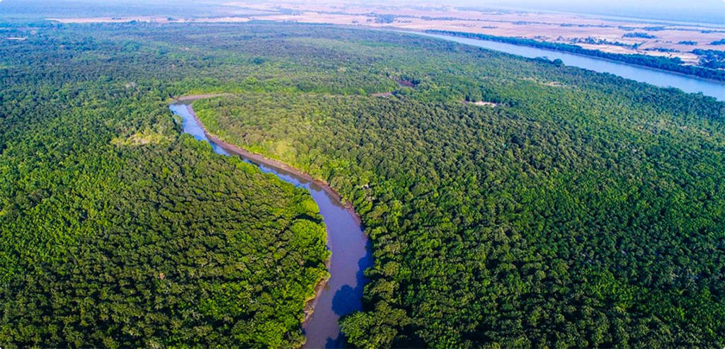
15.1 Mangroves
Mangroves are salt-tolerant coastal forests found in intertidal zones.
They provide:
- Reduction in wave energy.
- Coastal stabilisation.
- Sediment trapping.
- Habitat for biodiversity.
- Carbon sequestration.
- Support for fisheries and livelihoods.
The Sundarbans are particularly important because they constitute one of the largest mangrove ecosystems in the world.
15.2 Coastal wetlands
Wetlands absorb and temporarily store excess water.
They can reduce the severity of flooding and provide important ecological services.
15.3 Sand dunes
Coastal sand dunes act as natural barriers against waves and storm surges.
Their destruction through unplanned construction and sand mining can increase coastal vulnerability.
15.4 Nature-based solutions
India should integrate ecosystem restoration with engineered coastal protection.
Important measures include:
- Mangrove restoration.
- Protection of coastal wetlands.
- Restoration of sand dunes.
- Conservation of estuaries.
- Sustainable coastal land-use planning.
Such approaches can provide long-term ecological and disaster-risk reduction benefits.
16. Challenges in India’s Cyclone Management
Despite considerable progress, India continues to face several challenges.
16.1 Forecasting uncertainty
Forecasting the precise landfall location and intensity of a cyclone remains challenging.
Small changes in the cyclone track can substantially alter the geographical distribution of damage.
16.2 Rapid intensification
Rapidly intensifying cyclones can reduce the time available for evacuation and emergency preparation.
16.3 Last-mile warning dissemination
Fishing communities, remote islands and isolated coastal settlements may not receive warnings in time.
16.4 Urban coastal vulnerability
Rapid urbanisation has increased exposure along parts of India’s coastline.
Unplanned construction, inadequate drainage and encroachment on wetlands can magnify cyclone-related damage.
16.5 Livelihood losses
Evacuation and fishing restrictions protect lives but may result in substantial income losses for fishing communities.
Disaster preparedness must therefore incorporate livelihood protection and timely compensation.
16.6 Infrastructure resilience
Electricity networks, telecommunications, roads, ports and water-supply systems need to be designed to withstand extreme weather conditions.
16.7 Regional cooperation
Cyclones do not respect national boundaries.
India requires continued cooperation with Bangladesh, Sri Lanka, Myanmar, Thailand and other countries in the region on forecasting, maritime safety and disaster response.
17. Way Forward: Towards a Disaster-Resilient Coastal India
India needs to move from a primarily response-oriented approach towards comprehensive disaster-risk reduction.
The following measures are important.
1. Strengthen impact-based forecasting
Warnings should communicate not only the expected cyclone intensity but also the likely impact on specific settlements, infrastructure, agriculture and fisheries.
2. Improve last-mile connectivity
Warnings should be disseminated through multilingual mobile alerts, local radio, fishing-community networks and trained volunteers.
3. Expand cyclone shelters
Shelters should be accessible to vulnerable populations and equipped with drinking water, sanitation, electricity and emergency medical facilities.
4. Strengthen coastal land-use planning
Construction in high-risk coastal areas, floodplains and ecologically sensitive zones must be regulated.
5. Protect natural coastal barriers
Mangroves, wetlands, dunes and estuaries should be integrated into coastal disaster-risk reduction plans.
6. Develop resilient infrastructure
Electricity, telecommunications, transport and water-supply systems must be designed to withstand extreme weather events.
7. Provide livelihood protection
Fishermen and agricultural workers affected by evacuation orders and weather-related restrictions require timely livelihood support.
8. Strengthen regional cooperation
India should enhance cooperation through the World Meteorological Organization, regional disaster-management mechanisms and bilateral arrangements.
9. Improve climate-risk assessment
Long-term coastal planning should incorporate sea-level rise, changing rainfall patterns and compound hazards.
10. Institutionalise post-disaster learning
Every major cyclone should be followed by systematic assessment of warning performance, evacuation effectiveness, infrastructure damage and recovery outcomes.
18. Conclusion
Tropical cyclones are a recurring geographical phenomenon in the North Indian Ocean. Their impact, however, is determined not only by meteorological intensity but also by coastal geography, ecological conditions, population exposure and the effectiveness of disaster-management systems.
The development of Cyclone Akvan once again highlights the importance of preparedness along India’s eastern coastline.
India has made significant progress in forecasting, early-warning dissemination, evacuation and specialised disaster response. Nevertheless, emerging challenges such as rapid intensification, sea-level rise, urban coastal vulnerability and ecosystem degradation require a more comprehensive approach.
The objective must be to build disaster-resilient coastal communities through scientific forecasting, effective governance, resilient infrastructure, ecosystem conservation and community participation.
A cyclone cannot be prevented, but its destructive consequences can be substantially reduced through preparedness, timely action and sustainable coastal development.
19. UPSC Examination Perspective
A. Syllabus linkage
| Paper | Relevant syllabus area |
|---|---|
| GS Paper I | Important geophysical phenomena; climatology; oceanography; geographical features |
| GS Paper I | Distribution of key natural resources and location of industries |
| GS Paper III | Disaster management |
| GS Paper III | Environmental pollution and degradation; climate change |
| GS Paper II | Government policies and interventions; institutional mechanisms |
| Essay | Climate resilience, sustainable development and disaster preparedness |
B. Important facts for Prelims
- Tropical cyclones are warm-core low-pressure systems.
- They rotate anticlockwise in the Northern Hemisphere and clockwise in the Southern Hemisphere.
- The Coriolis force is weak at the equator.
- Warm ocean waters and low vertical wind shear favour cyclone development.
- The North Indian Ocean experiences two principal cyclone seasons: pre-monsoon and post-monsoon.
- The Bay of Bengal generally experiences more cyclone activity than the Arabian Sea.
- Storm surge is distinct from a tsunami.
- IMD is the Regional Specialised Meteorological Centre for tropical cyclones over the North Indian Ocean.
- NDMA was established under the Disaster Management Act, 2005.
- Mangroves and coastal wetlands contribute to ecosystem-based disaster-risk reduction.
C. Mains practice questions
1. GS Paper I
Why does the Bay of Bengal experience greater tropical cyclone activity than the Arabian Sea? Explain the geographical and oceanographic factors responsible.
2. GS Paper I
Explain the conditions necessary for the formation of tropical cyclones. Discuss the structure and major hazards associated with them.
3. GS Paper III
India has significantly improved its cyclone forecasting and early-warning systems, but coastal vulnerability continues to pose serious challenges. Examine.
4. GS Paper III
Discuss the importance of ecosystem-based disaster-risk reduction in protecting India’s cyclone-prone coastal regions.
5. GS Paper III
Examine the relationship between climate change, sea-level rise and the increasing risks associated with coastal disasters.
Official reference links
- IMD – Cyclone Akvan Forecast Bulletin, 16 November 2026
- IMD – Tropical Cyclone Advisory, 16 November 2026
- IMD – Cyclone Warning in India: Standard Operating Procedure
- NDMA – National Guidelines on Management of Cyclones
- National Institute of Disaster Management – Cyclone Management Guidelines
- NOAA – Tropical Cyclone Formation and Structure
- World Meteorological Organization – Tropical Cyclone Conditions